Monday at 6: 30 a. m. ET, forecasters confirmed incoming snow flurries and the potential for accumulating snowfall across the B. C. South Coast, including Metro Vancouver, altering short-term vancouver weather patterns for the week. The timing is driven by a rare cold-air migration from eastern Siberia and Alaska that is now interacting with Pacific moisture over the Gulf of Alaska.
Vancouver Weather Forecast Details for Metro Vancouver and Coastal Areas
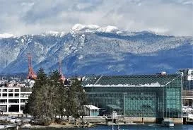
Higher elevations of Metro Vancouver should prepare for measurable snowfall: models indicate 5–10 cm of accumulation above 200 metres in elevation. Locally, some pockets may see 5–15 cm where convective bursts of snow set up, while lower-lying sections can expect little to no accumulation in many neighborhoods.
Snow-showers are forecast to extend from Haida Gwaii and Prince Rupert down toward northern Vancouver Island and southern locations, with coastal spots such as Tofino flagged for rare snowfall events. Greater Victoria locations including the West Shore and the Malahat have the potential for a few centimetres through Monday night.
How the Gulf of Alaska Shift Triggered This Week’s Snow
An anomalously cold air mass over eastern Siberia and Alaska has migrated across the Gulf of Alaska and begun interacting with Pacific moisture; that interaction is the immediate trigger for the South Coast’s burst of wet snow. A weak low continuing to swirl northwest of Haida Gwaii will feed unstable, cooling air a few hundred metres above sea level, producing wet snow at lower elevations than usual.
Models show the freezing level will lift and fall through the week: temperatures warm aloft by midweek, pushing the freezing level toward about 600 metres above sea level by Wednesday, then colder below-seasonal air returns Thursday night into Friday for another chance at lower-elevation snow. For vancouver weather impacts, that means two distinct windows for snow on the South Coast this week.
Avalanche Risk, Ski-Resort Gains and a Notable Date for YVR
Ski resorts along the B. C. South Coast stand to benefit: the region looks to enter one of the snowiest periods of the season, with forecasts calling for more than 100 cm across parts of Vancouver Island and the Coast Mountains over the course of the week. Avalanche risk will fluctuate, and considerable to high danger is expected to be the norm over the next seven days.
It’s now been over a year since Vancouver airport (YVR) recorded accumulating snowfall, dating back to Feb. 8, 2025, a mark that underscores how unusual lower-elevation accumulation would be for Metro Vancouver this season.
Snowfall amounts will be highly localized; some communities could escape significant totals while nearby higher-elevation pockets see close to 10 cm from heavier convective bursts.
Forecasters will monitor the weak low northwest of Haida Gwaii and its temperature profile aloft to refine localized forecasts for the Sunshine Coast and the Fraser Valley, where accumulating snow is also possible if colder air reaches valley floors.
More details expected Thursday at 8: 00 a. m. ET; if the cold-air pool deepens as models currently suggest, additional lower-elevation accumulation is expected by Thursday night into Friday.