Saturday at 3: 00 p. m. ET — Environment Canada issued a heavy snow warning for Calgary, confirming 10 to 20 centimetres of snow expected to begin Sunday morning and intensify through the afternoon and evening. Yet the exact local placement and final totals are unconfirmed as of Saturday at 3: 00 p. m. ET; forecasters say the noon shift from a rain-snow mix to heavy snow and the position of a sharp cold front will determine outcomes.
Heavy Snow Warning: Environment Canada Forecast for Calgary
Environment Canada confirmed a snowfall warning issued Saturday afternoon calling for heavy snowfall of 10 to 20 centimetres expected to begin Sunday morning, with the storm intensifying quickly and peaking through the afternoon and evening. Still, forecasters list a timeline inside the warning: the event will start as a mix of rain and snow Sunday morning, shift to heavy, steady snowfall near noon with up to 10 centimetres expected through the day, and add another 5 to 10 centimetres Sunday night before tapering off early Monday morning.
High Winds and Highway Threats South of Calgary
Wind warnings are in place with powerful gusts expected across southern Alberta; some areas could see gusts of 80–90+ km/h and wind gusts to 100 km/h are possible in the early afternoon across southern Alberta. Yet highways 1, 2, 3, and 22 near and south of Calgary are forecast to experience the worst conditions, with whiteouts and rapid visibility reduction identified as immediate travel hazards for drivers preparing for Sunday.
Forecast Confidence, Cold Front Placement, and When Observations Will Clarify
Exact snowfall amounts remain low-to-moderate confidence as of Saturday at 3: 00 p. m. ET because this setup hinges on a smaller-scale temperature boundary; the location of the heaviest snow will vary along the front, conditional on the placement and lift generated by that extreme temperature boundary. Yet the frontal squall is confirmed as the focus for whiteout conditions and the heaviest snowfall, meaning observational reports of where the frontal band sets up will resolve the biggest unknowns.
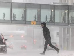
Still, the forecast includes a rapid temperature drop that is already expected with the approaching cold front: daytime highs that were above seasonal on Saturday are predicted to plunge, with Environment Canada noting temperatures will fall to around –3 C by Sunday afternoon and feel closer to –10 with wind chill. That confirmed temperature shift will reinforce the transition to all-snow and sustain hazardous road icing once the precipitation changes over.
Yet uncertainty remains about exact storm placement across the city and nearby southern corridors; small shifts in the front will produce big swings in local snowfall over short distances, unconfirmed as of Saturday at 3: 00 p. m. ET. Observable triggers that will clarify the picture include the midday observation of the rain-to-snow transition in Calgary, radar confirmation of the frontal squall line as it moves through, and wind-gust reports across southern Alberta.
Drivers are urged to prepare for Sunday travel risks with the winds and snow-related disruptions already flagged in official warnings. For commuters and freight operators on Highways 1, 2, 3, and 22 near and south of Calgary, the combination of heavy, steady snowfall, gusty winds, and rapidly falling temperatures is the confirmed hazard that will determine whether roads become impassable.
The next confirmed milestone is the forecast tapering of the storm early Monday morning ET, which Environment Canada lists as the end of the heaviest impacts. If the cold front and frontal squall place the heaviest snow over Calgary as currently warned, widespread travel disruptions are expected through Monday; if the front tracks farther south, then southern highways will face the brunt while inner-city Calgary sees lower totals and shorter-duration impacts.