A large Kona storm moving north of the islands is producing Hawaii Flash Flooding as it pulls up deep tropical moisture, prompting extended flash flood warnings, road closures and damaging southerly winds across multiple islands.
Storm Overview and Short-Term Timeline
The First Alert Weather Team has declared First Alert Weather Days as the Kona low sends heavy rain and strong to severe thunderstorms over the state. The storm is expected to produce an extended period of flash flooding, damaging winds and strong thunderstorms through Saturday morning, then extend east to Maui County and Hawaii Island into much of Saturday afternoon and evening. Snow and ice are also expected over the highest Big Island summits.
Southerly to southwesterly winds will be strongest early in the event, producing damaging gusts. The main band of heavy showers is forecast to shift eastward and may stall between Maui and Hawaii Island, which would exacerbate flooding in those areas.
Hawaii Flash Flooding: Warnings, Road Closures and Local Impacts
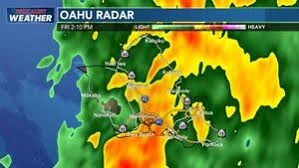
Flash flood warnings remained in effect late Friday night across multiple islands as heavy rainfall continued to cause flooding and road closures. On Oahu, the flash flood warning is in effect until 12: 30 am ET Saturday, with flooding problems still being reported despite rainfall beginning to ease.
On Hawaii island, heavy rain fell over the Puna and Kau districts along the southeast slopes. Emergency officials closed Wood Valley Road in both directions due to flooding, and the flash flood warning for the island was extended until 12: 30 am ET Saturday.
Maui County saw heavy south-facing rain from Maalaea Bay through Kihei and Makena to Kipahulu; the Maui flash flood warning was extended until 3: 00 am ET Saturday. Several road closures were reported in Kihei and Lahaina because of significant flooding.
Molokai experienced heavy rain and high water flowing across Kamehameha Highway near mile marker 6, where the road remained passable only to four-wheel-drive vehicles. The flash flood warning for Molokai was in effect until 12: 00 am ET. The Kawela Gulch stream gauge remained elevated, with water flowing over Kamehameha Highway at the Kamalo Dip between mile markers 10 and 11; that stretch remained passable at the time but may close if heavy rain continues.
What Residents Should Expect Through The Weekend
Thunderstorms and heavy showers will continue into the weekend, with the initial band of storms expected to stall over eastern Maui Saturday afternoon and evening. Pop-up thunderstorms could lead to quick runoff because the ground is saturated in many places; any additional rainfall could produce rapid flash flooding.
Flash flooding and breezy southwest winds are expected to persist for Maui County and Hawaii Island on Sunday, with possible extension into Monday for Hawaii Island. Flooding threats for Kauai and Oahu are expected to decrease through Sunday, but saturated soils mean even isolated downpours may trigger more runoff and flash flooding.
Authorities continue to monitor conditions as the storm moves across the state. Residents in affected areas are urged to heed local road closure notices and remain prepared for rapid changes in conditions while the Kona low continues to affect the islands.