Major seasonal models and NOAA observations now show that a long-running weak La Niña is ending quickly and that el niño is likely to form: forecasts moved in a week from roughly 60–70% neutral toward an 80% probability of a strong or very strong event before the end of summer. This shift raises near-term risks for regional rainfall, temperatures and global climate impacts.
NOAA Signals El Niño Return
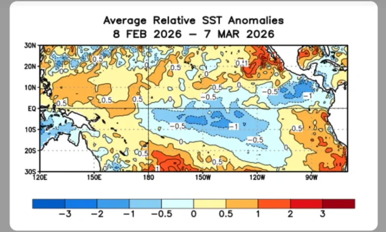
NOAA has detected significant subsurface warming in the equatorial Pacific and Kelvin waves are transporting heat eastward, and those ocean signals are the classic first signs that an El Niño is beginning to develop. The pattern suggests this is not a gradual swing: three episodes this year of warm water moving from the western Pacific to the east, combined with observed changes in wind patterns, have pushed model probabilities rapidly toward a strong or very strong ENSO event.
ECMWF Forecasts Chile Impact
The European Centre for Medium-Range Weather Forecasts (ECMWF) has anticipated the arrival of El Niño, and Chilean meteorologist Jaime Leyton has said a normal-to-moderate event could affect the country from Coquimbo to La Araucanía. Leyton places a 60%–70% probability that increased precipitation will establish in central Chile at the end of autumn, with winter conditions extending into spring across Coquimbo, Biobío and La Araucanía.
The figures point to a regional shift toward wetter-than-normal conditions in central Chile if the ECMWF signal holds, which would alter agricultural and water-management expectations for those named regions.
Inocar Monitoring Ecuador Conditions
The Instituto Oceanográfico y Antártico de la Armada del Ecuador (Inocar), through commander Santiago Coral, emphasizes caution: current monitoring shows normal temperature tendencies in Niño 3+4 and Niño 1+2 regions and no detectable alterations in any of the three areas Inocar tracks. Inocar also notes ENSO events begin to develop at the end of April, effects become assessable in September and October, and peaks generally occur between November and March.
That assessment leaves Ecuador’s status unresolved for now: Coral says it is premature to conclude there will be an El Niño in 2026 for Ecuador, and Inocar will keep monitoring the three Niño zones and climatic conditions before changing that judgment.
Beyond regional forecasts, several outlets and scientists cite the potential for a very strong event to rival past super El Niños. Historical comparison matters: the 1997–98 super El Niño is highlighted as a precedent because it was among the most intense on record and is estimated to have reduced global economic growth by about 5. 7 trillion dollars. Scientists quoted in recent summaries also warn that a strong El Niño would likely raise global temperatures, potentially making 2027 the warmest year on record if the event develops as signaled.
The implication is clear: if subsurface warming persists and seasonal model consensus strengthens, the world could face a cluster of impacts—droughts in Australia, Indonesia and parts of eastern Africa and the Caribbean, and torrential rains in Peru, Ecuador and Hawaii—that would test food, water and disaster-preparation systems already under strain.
For now, the next confirmed milestone is the established schedule for ENSO monitoring: development typically begins at the end of April, with meaningful effects evaluated in September and October and a peak between November and March. If the current subsurface heat and wind-pattern changes endure through the spring, the monitoring data available in September will provide the decisive evidence about how strong any el niño will become.