A potent blizzard ‘bomb’ sweeping the Midwest has left minnesota facing heavy snow and travel chaos, with airports across the region experiencing thousands of delays and cancellations and several communities recording historic accumulations.
Minnesota Snow Totals and Airport Disruptions
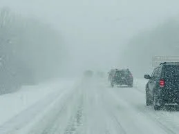
Parts of southeastern minnesota have seen more than 20 inches of snow as the storm moved through on Sunday afternoon, and blizzard warnings were in place for the Minneapolis area. Runway capacity at Minneapolis–Saint Paul was sharply reduced by the record snowfall, and FlightAware data put cancellations at the Minneapolis–Saint Paul international airport at more than 600 for the day.
Nationally, the disruption has been widespread. FlightAware recorded 11, 717 flight disruptions within, into, or out of the country as of Sunday evening, a total that included 3, 319 full cancellations and 8, 398 delays through Monday so far. Major carriers issued broad travel waivers as the ripple effects reached hubs and the I-95 corridor.
Record Totals Across the Upper Midwest and Travel Paralysis
The same storm produced extraordinary totals farther east and north. Spalding in Michigan’s Upper Peninsula logged 26. 0 inches of snow, with snowfall rates reported at up to 3 inches per hour and wind gusts near 60 mph that produced extensive drifting. Travel was described as impossible across Menominee County and much of the central U. P.
Green Bay recorded 14. 8 inches of snow as of 5: 00 pm ET, marking the city’s third-snowiest day on record and its snowiest single day in 137 years. An area stretching from central Wisconsin into parts of the Upper Peninsula was expected to see totals exceeding two feet, with higher isolated amounts on the peninsula, creating hazardous conditions for commuters and emergency services.
Severe Weather Threat Eastward and Airport Ground Stops
The storm system has been described as a “triple-threat” event combining blizzard conditions, damaging winds and severe thunderstorms that threaten a large portion of the eastern United States as it pushes east. Forecasts warned of damaging straight-line winds and a possibility of a few tornadoes in the mid-Atlantic region, with an elevated threat for areas from parts of South Carolina to Maryland during Monday afternoon.
The FAA imposed ground stops in Chicago as thunderstorms forced temporary halts at both O’Hare and Midway airports. O’Hare’s ground stop was in effect until 9: 00 pm ET, and Midway’s restriction lifted at 8: 00 pm ET, holding inbound flights at their departure points until local traffic could resume. Chicago-area ground stops, coupled with heavy snow at Midwest hubs, contributed to cascading delays elsewhere across the national network.
Along the eastern seaboard and into New England, forecast models signaled the risk of intense downpours that could produce brief bursts of 0. 5 to 1 inch of rain in less than an hour in some urban areas, raising localized flooding concerns. The National Weather Service warned that a line of severe storms would cross the Mississippi, Tennessee and Ohio valleys before moving into the Appalachians and toward the Atlantic coast, where severe thunderstorms with widespread damaging winds were expected.
What Comes Next
With the storm still unfolding, communities and transportation networks face continued disruption. Airlines have adjusted operations and extended waivers, and ground stops and cancellations may extend ripple effects into the coming days. Emergency and public-safety officials in affected areas have been dealing with deep snow, high winds and the risk of localized flooding as the system moves eastward.
Authorities cautioned that conditions remained hazardous where snow rates, drifting and high winds persisted, and travel was likely to remain difficult in many parts of the Upper Midwest through the immediate aftermath of the storm. The outlook called for the system to carry both winter and severe-weather hazards into the eastern U. S., creating a complex response challenge for affected jurisdictions.