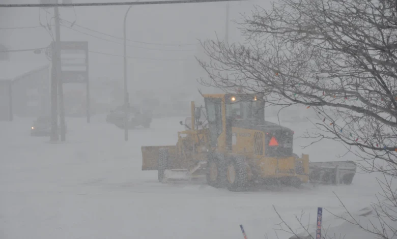
Wednesday at 7: 00 a. m. ET — environnement canada has issued a special weather bulletin confirming a major winter storm will produce 20 to 40 centimeters of snow in a 24-hour period starting Wednesday, affecting Bas-Saint-Laurent, Gaspésie and the Côte-Nord. What remains unresolved is the precise timing of peak snowfall and which routes or services will close; those details will be clarified by operational notices from local transport authorities.
Confirmed storm details from Environnement Canada
CONFIRMED: environnement canada has forecasted a total accumulation of 20 to 40 cm of snow over roughly 24 hours, beginning Wednesday, in regions that include Bas-Saint-Laurent, Gaspésie and the Côte-Nord. The bulletin specifies accompanying winds of 60 to 70 kilometers per hour. These figures are presented in the agency’s special weather bulletin and constitute the core confirmed meteorological threat.
Bas-Saint-Laurent, Gaspésie and Côte-Nord: specific impacts under notice
Still, Environnement Canada lists direct impacts: expected conditions of blowing snow and severely reduced visibility that will make travel difficult. The advisory says there will possibly be delays and cancellations in transportation and that road closures are possible. Bas-Saint-Laurent and the Côte-Nord coastal corridor are explicitly named in the advisory as areas under the special bulletin.
Visibility, winds and the operational triggers that will resolve uncertainty in Gaspésie
UNCONFIRMED as of 7: 00 a. m. ET: which specific road segments, ferry crossings or scheduled services will be suspended. The bulletin warns of possible delays and cancellations but does not list confirmed closures. The immediate observable triggers that will resolve this uncertainty are: measured wind gusts reaching the forecasted 60–70 km/h threshold, recorded snowfall totals hitting the lower or upper end of the 20–40 cm range at reporting stations in Gaspésie and neighbouring regions, and operational advisories issued by regional transport operators.
Yet, each of those triggers is concrete and trackable. Local meteorological observations that show sustained visibility drops due to poudrerie (blowing snow) and automated road sensors reporting hazardous conditions will be the first formal indicators prompting route advisories or closures in the Bas-Saint-Laurent corridor.
That said, the advisory’s language—specifically that “road closures are possible”—means closures remain conditional and are not confirmed as of the bulletin time. UNCONFIRMED as of 7: 00 a. m. ET: any confirmed schedule changes for ferry services on the Matane–Baie-Comeau–Godbout corridor or the timing of municipal road closure orders.
Still, the forecasted numbers give emergency planners and travelers concrete thresholds to watch: 20–40 centimeters of snowfall in 24 hours and winds between 60 and 70 km/h. When either measured snowfall or sustained wind speeds match those thresholds at reporting sites in Gaspésie or the Côte-Nord, officials are expected to move from advisories to operational actions such as cancellations.
Closing: The confirmed next event that will move this story is the start of the storm on Wednesday at 7: 00 a. m. ET, when regional observations will begin to register snowfall and wind trends tied to the bulletin. If snowfall accumulations reach the forecasted 20 to 40 cm during the 24-hour window, then road closures and travel cancellations are expected to be issued by local authorities within hours of those measurements.