Montreal Weather residents in the greater Montreal area and neighboring regions face the prospect of power outages, tree damage and crippled travel as a forecasted ice event could dump heavy freezing rain midweek; Sunday at 10: 00 a. m. ET Environment Canada issued a special weather statement warning of freezing rain on Wednesday.
Who in the Montreal area and nearby regions would see outages and travel disruption
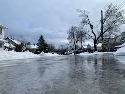
Up to 30 millimetres of freezing rain could fall over 24 hours from Wednesday to Thursday, creating the accumulation most likely to cause downed branches and outages. The statement explicitly covers the greater Montreal area plus Montérégie, Outaouais, the Laurentians, Lanaudière, Mauricie, Centre-du-Québec and the Capitale-Nationale regions, giving people in those named areas time to change travel plans and prepare for service interruptions.
Environment Canada special weather statement lays out the freezing rain forecast
In its statement, Environment Canada warned “a potentially critical freezing rain situation is forecast, ” signaling a higher-than-usual risk for hazardous ice accumulation that could paralyze some services. The agency also noted a cold snap following the precipitation could complicate and delay full restoration of affected services, increasing the window of impact on power and transportation systems.
Storm dynamics across Ontario and Quebec that may worsen impacts on Montreal
A messy storm system moving into Ontario and southern Quebec is expected to bring warm air aloft over a stubborn slab of subfreezing surface air, a setup that increases the potential for freezing rain across southern Quebec into Wednesday. A large centre of low pressure over the Mississippi Valley is forecast to slice across southern and eastern Ontario through late Wednesday, while precipitation is expected to build in Ontario beginning Tuesday night and extend eastward toward the Montreal region.
Still, the same system is tied to additional risks elsewhere: some areas may see significant freezing rain that leads to tree damage and power outages, and wind gusts behind the cold front are forecast to increase, which could further stress already weakened trees and power lines.
That said, short-term temperature swings will matter locally. Forecasts in the statement show it will feel like spring at the start of the week — a high near 13 C on Monday with an overnight low of plus 5 C, then about 14 C Tuesday during the day before temperatures fall to around zero overnight Tuesday — conditions that help set up the warm-over-cold profile that leads to freezing rain.
For now, Ottawa and Montreal are specifically called out as cities that should pay close attention to the forecast over the coming days because a major weather event is possible for those population centres.
If the current forecast holds, up to 30 millimetres of freezing rain is expected to fall over 24 hours starting Wednesday; more details expected Wednesday at 9: 00 a. m. ET.